
Map a Glendale Street by Address
A street directory search in Glendale works best as a chain of evidence, not as one all-purpose name list. Begin with the physical address, identify the county parcel, and keep the Assessor Identification Number, or AIN, with every later note. The parcel record can show characteristics, assessed values, and transfer clues. It cannot, by itself, prove who sleeps at the address. A deed ties a named party to a legal transfer, a permit ties a person or firm to a project, and a historical directory may list a household member for one publication year. Those are different relationships and should stay separate.
The order below keeps a street-by-street search workable even when one office cannot answer the next question.
- Normalize the address. Compare the typed street line with the Los Angeles County Assessor Portal. Search by AIN or address, and keep the result's city and ZIP with the parcel note.
- Open the map view. Use the LA County Assessor Map and Glendale's official city map catalog to see boundaries, nearby parcels, and historic or zoning context. The Glendale GIS service catalog supplies machine-readable layers for streets, ZIP codes, neighborhoods, and historic parcels.
- Record each AIN. Click the subject parcel and each adjacent parcel separately. A corner, condominium, commercial site, or newly enrolled parcel may not accept the address form a researcher expects.
- Translate land into a deed search. The county Recorder does not index real-estate documents by address or APN. Obtain a named party or document number first, then use the recording year and document title to request the instrument.
- Add household-era evidence. For an earlier address listing, use the Glendale History Room's reverse sections and cross-check the name in the alphabetical half. Voter verification is for the person who supplies the required fields, not a street-browse tool.
Note: The AIN and legal description can hold a street search together when a typed address changes across maps, permits, or old directories.
Glendale Street Directory Records
Several public record sets can be lined up around an address, but each has a different keeper and limit. The following coverage view separates parcel geography, ownership evidence, project history, and listed people. It is the core of a responsible Glendale street directory because it prevents a map result from being mistaken for a resident result.
| Record Set | Keeper | What It Shows | Access |
|---|---|---|---|
| Current assessment | Los Angeles County Assessor | AIN, situs, parcel characteristics, values, and transfer clues | Free address/AIN portal; owner information through an office or data channel |
| Parcel and map layers | Glendale GIS and LA County Assessor Map | Boundaries, adjacent parcels, streets, ZIPs, zoning, neighborhoods, and historic context | Free public map and service catalog |
| Deeds, liens, and releases | Los Angeles County RR/CC | Named parties, recording details, legal descriptions, and an ownership chain | In-person or mail request by party or document; paid copies; no address/APN index |
| Voter verification | LA County Registrar-Recorder/County Clerk | A supplied person's registration status tied to supplied house number and ZIP | Four-field self-check; broader files require a permitted request |
| Permits and code cases | Glendale Community Development | Address or parcel work history, case status, applicants, contractors, and dates | Tyler EnerGov public search; archive request for missing material |
| Telephone and reverse directories | Glendale History Room | Listed names, occupations, addresses, and some address-first entries by year | Appointment and reference access; runs are not continuous |
Use the AIN as the bridge between the first two rows. A named owner or deed party can then lead to the RR/CC index. A permit applicant may explain a change to the building without proving residence, while a reverse directory entry may show a listed occupant without proving ownership. The value comes from agreement among records, not from forcing every row to answer the same question.
Search a Glendale Street Directory
The LA County Assessor Portal is the practical first stop for an address-based street directory search. Its public web route accepts an AIN or a situs address, not an owner name. The Assessor map help explains the owner-name restriction and notes that address anomalies can require a nearby cross-street or map approach. Owner information is available at Assessor offices or through Property Data Sales, but it is intentionally not displayed in the public web result.
| Field Label | Type | Required | Options / Format Notes |
|---|---|---|---|
| Basic Search | Button or tab | No | Standard address or AIN search |
| Legal Search | Button or tab | No | Legal-description-oriented route |
| Search by AIN or Address | Text or autocomplete | Yes | AIN or situs address; multiunit, corner, and new parcels may use a different enrolled address |
| Map Search | Button or tab | No | Pan, zoom, and click parcels |
| Assessor Internet | Navigation | No | Opens the assessment detail view |
A parcel result can include the AIN, property address, city and ZIP, legal description or map reference, property use, land and improvement assessed values, tax-rate area, transfer indicators, and building characteristics when available. The public owner field is absent. Glendale's 912-series ZIP line, typed street address, corner parcel, and multiunit address can point to different enrolled forms. Mailing and situs fields should also be kept apart, since a mailing location can differ from the physical parcel.
Transfer-price quirk. The Assessor's indicated sales price is derived from Documentary Transfer Tax and may copy leading digits at the end. A display such as $450,004 is a transfer-tax signal, not a literal sales-price display.
Glendale GIS Street Layers
A street-by-street review gains its geographic frame from map layers. After locating the subject parcel in the Assessor map, compare it with Glendale's parcel and zoning viewers, then inspect the public GIS catalog for Streets, NeighborhoodZones, GlendaleZIPCodes, HistoricDistricts, HistoricParcels, libraries, HOA areas, and the city boundary. The layers show where land sits and how the city describes it. They do not disclose a household roster.
For a whole-street pass, zoom until parcel outlines are clear, click one parcel, write down its AIN, and pan along both sides of the road. The Assessor help route recommends nearby cross streets when an address fails. Glendale's map catalog is useful when the question turns to a historic parcel, a zoning line, a neighborhood edge, or a city-limit mismatch. Condo units, corner sites, and parcels with a changed enrolled address deserve a separate map check rather than a guessed match.
GIS also supplies a clean way to distinguish an adjacent parcel from a similarly named address. That matters when an old street entry, a modern parcel card, and a deed use different forms of the same location.
Glendale Street Address Definitions
Address records use terms that sound alike but do not identify the same thing. A parcel search becomes clearer when the location field is named before a conclusion is drawn. The physical site, a tax mailing point, a legal lot, and a listed household can all be connected while still describing different facts.
- Parcel
- A mapped unit of land identified in county assessment work by an AIN. A parcel can contain more than one unit or structure.
- Situs address
- The physical location used to place the assessed property. It is not automatically a mailing address or a list of occupants.
- Mailing address
- The destination for assessment or tax correspondence. It may differ from the situs and cannot alone prove where an owner lives.
- Plat
- A recorded map that lays out lots, blocks, streets, and related land divisions. Glendale's 1887 town plat is an important historical anchor.
- Criss-cross directory
- An address-order section that can list names or businesses by street and number, when that edition includes the section.
These definitions explain why a parcel map and a directory can both be accurate while naming different people. A legal description and AIN are stronger continuity clues than a street string copied from a later map.
Glendale Deeds Need a Party
Los Angeles County's Registrar-Recorder/County Clerk, or RR/CC, does not offer an Internet deed index searchable by street address or APN. A request needs a document number, or a recorded party name paired with the recording year and document title. That rule changes the order of an address investigation: first translate the address into a named owner or deed party through the Assessor's authorized channels, an existing instrument, or title evidence, then search the county index.
Norwalk headquarters is at 12400 Imperial Highway. By appointment, records from 1851-1957 are reviewed on the lower level and records from 1958-present on the upper level. Branch offices commonly provide real-estate copies from 1982-present, while older index work belongs at Norwalk. The RR/CC branch information and contact directory provide the current service route; the general recorder/clerk number is (800) 201-8999, and recorder@rrcc.lacounty.gov is the listed email.
The cited copy schedule is $6 for the first page and $3 for each additional page. A real-estate search by name and year is $0.50. Requests can be made by mail or in person, but the requester must supply enough party, year, and title information for staff to work. Once the acquisition deed is found, follow its grantor backward as an earlier grantee and compare the legal description at every step.
Note: The county's viewer series uses 1851 as the practical start here, although another county page describes the earliest holding as 1850.
Glendale Permit History Since 2005
Glendale's current public permit route is the Tyler EnerGov search. The search can work from a case or permit identifier, address, parcel, or other record detail, with map and reset controls available in the public interface. The older city form states that legacy public coverage begins in 2005 and is incomplete, so a blank result should not be read as proof that no permit exists.
Permit data can add a date to construction or alteration work and may identify an owner, applicant, architect, contractor, or case status. That is evidence of a project connection, not proof that any named person lived at the address. Code cases can add another address-based trail, while protected complainant or personal information may be withheld.
The Glendale EnerGov permit search capture shows the public search interface used for current address research.
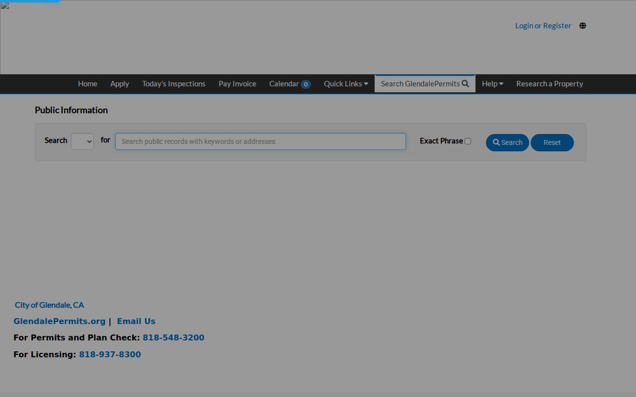
The image places the permit trail in its proper role: a searchable city record that can supplement parcel and deed evidence, not replace a named-party or household source.
Request Missing Glendale Permit Files
When Tyler EnerGov lacks an older or omitted case, use Glendale's direct permit-record request form. The form is built for address research and lets a requester supply several locations at once. It is a practical fallback for work that reaches beyond the public portal's stated coverage.
- Provide the date, requestor name, requestor address, email, phone, signature, and date.
- List up to six requested addresses on the form, or attach a separate sheet when more space is needed.
- Send the request by email to PSCApplication@glendaleca.gov or by fax to (818) 548-3215.
- Allow up to ten days; Building & Safety is at 633 E. Broadway, Room 101, and its phone is (818) 548-3200.
For other existing city records, the Glendale City Clerk public-records request accepts a detailed description and can route a property request. City Hall is at 613 E. Broadway, Room 110. The city says it can provide notices of availability or exemptions within ten days, which is a determination notice rather than a promise that every file will be complete then.
Glendale does not supply county deeds, county vital records, or county real-property ownership inquiries through City Hall. Route those questions to the RR/CC or Assessor instead of repeating a city request.
Glendale Reverse Directory Years
The Glendale History Room preserves the older street-reading layer that modern parcel tools cannot replace. Telephone directories run from 1908-1977 in the listed collection, and reverse or address sections begin in the teens. Reverse use is documented for 1917, 1919, and 1922. An address-first search scans the street range, records every printed name, and then checks the alphabetical section for occupation, spouse, business, or residence clues.
Access is by appointment at the History Room, where much of the material is closed-stack and reference-only. Read the abbreviation key for the exact edition before treating a mark as a residence, business, household, or ownership signal. A missing name can mean an unlisted person, an omitted household member, a gap in the volume, or a changed street number.
For the complete shelf and scan map, the Glendale city directory collections page keeps the historical editions together. The address-search use case remains narrower: read one address range, bridge the old name to the modern parcel, and record the year beside every entry.
Note: A reverse section exists only in particular editions, so a missing address line is a gap in that volume, not proof that no household was present.
Glendale Street Name Changes
Old Glendale street research can fail when a modern name is carried backward without checking the local map history. The town plat was recorded in 1887, the city incorporated in 1906, and annexations changed the governmental frame around older parcels. By 1920, nine annexations had expanded Glendale beyond 7,000 acres. Later additions helped bring the incorporated city to roughly 30.5 square miles. A directory entry may therefore reflect a different municipal edge or street label even when the land is the same.
The 1918 Tropico annexation brought a major renaming and renumbering break. The documented changes include:
- First became Lexington Drive.
- Second became California Avenue.
- Third became Wilson Avenue.
- Fourth became Broadway.
- Fifth became Harvard Street.
- Sixth became Colorado Street.
San Fernando Road and other streets were also significantly renumbered in 1918. Bridge a difficult entry with the AIN, legal description, historic parcel layer, Sanborn sheet, and the nearest directory key. The result is more reliable than a literal search for a current street string in an old index.
Limits of a Glendale Street Directory
A Glendale street directory cannot show every person connected to a block. Public property evidence may identify an owner or mailing location, but ownership is not occupancy. A permit names a project participant, not a continuous household. A reverse directory includes only people the publisher listed, and the voter verification form is designed for a person to check their own registration with last name, birthdate, house number, and ZIP.
California voter information is controlled by Elections Code sections 2180-2194. The four-field self-check at LA County Voter Registration Verification is not a browse-by-street resident directory. Broader voter-file products require a permitted request and declaration. DMV address information, utility customer data, unlisted phone numbers, household details, and protected Safe at Home addresses are not open substitutes; the California Secretary of State program explains the protected-address route.
Lawful personal use. Glendale address records support family history, property curiosity, reconnecting, and civic research. Using them to stalk, harass, intimidate, or harm someone is not lawful and may trigger California penalties.